

The 1.2 trillion yuan Yarlung Tsangpo River hydropower project: could it become the next Jilong Port? (Video)
[People News] Hello, dear viewers, and welcome to "Forbidden News Unveiled." I am Sun Ning.
On the ancient and mysterious Qinghai-Tibet Plateau, nature's retribution often goes unnoticed, yet it can swiftly obliterate human arrogance.
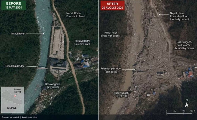
Recently, the Jilong Port on the China-Nepal border faced a devastating "high-altitude ice collapse and mudslide" disaster. Glaciers collapsed and liquefied within minutes, carrying centuries of accumulated debris through the river valley, instantly destroying permanent structures along the river and resulting in thousands of fatalities.
The tragedy at Jilong exposed the extremely fragile geological defenses of the Qinghai-Tibet Plateau in the context of climate change, serving as a stark warning to all those who seek to undertake large-scale construction in this region.
Nevertheless, this natural warning did not deter the grand ambitions of those in power. Just a year prior to the Jilong disaster, a hydropower project on the lower reaches of the Yarlung Tsangpo River, with a staggering total investment of 1.2 trillion yuan and a scale comparable to three Three Gorges Dams, officially commenced in this highly dangerous area of tectonic activity.
In response, the Chinese Communist government established a new first-level central enterprise, China Yajiang Group Co., Ltd. They are attempting to embark on the largest trillion-dollar gamble in human history at the most perilous and unstable tectonic plate boundary on the planet.
The ruins at Jilong Port remain uncleared, with the looming threat of nature hanging overhead. This super hydropower station, awkwardly inserted into the Grand Canyon, raises the question: is it a 'miracle' of human ingenuity triumphing over nature, or is it merely the next tragedy waiting to be erased, magnified a hundredfold like the Jilong disaster?
The Trillion-Dollar Gamble of the Yarlung Tsangpo Project
To fully grasp the stakes of this gamble, we must first examine the design blueprint emerging from the deep mountains of Linzhi, which challenges conventional physics.
As the roaring Yarlung Tsangpo River flows from Milin City in Tibet to Motuo County, it faces the formidable barrier of the Himalayas, forcing it to make a nearly 180-degree turn. The river winds through this extremely steep canyon for hundreds of kilometers. Remarkably, if this lengthy river section were to be straightened, its linear distance would only measure about 50 kilometers. Yet, within this short span, the river's natural drop reaches an astonishing 2000 meters.
What does a drop of over 2000 meters signify? It indicates that the river achieves a nearly vertical and frenzied descent over a very short distance. For decision-makers who prioritize GDP and political KPIs above all else, this is not merely the 'last secret realm of the Earth'; it is, in fact, the most perfect 'giant hydropower ATM' granted by nature.
The Chinese government has planned five tiered power stations in this area, with a total installed capacity ranging from 70 million to 81 million kilowatts, and an estimated annual power generation of 300 billion kilowatt-hours. This output is three times that of the Three Gorges Dam.
To harness this power, engineers from the Chinese Communist Party (CCP) have moved away from traditional high dam locks on the river, opting instead for a complex underground water diversion network referred to as 'two reservoirs and three dams.'
At the very upstream of the Yarlung Tsangpo River's great bend lies the Milin Hydropower Station, where the first high dam was constructed, establishing the 'head reservoir' for the entire project. This reservoir is specifically tasked with the long-term regulation of water volume from upstream.
The actual gatekeeper at the entrance of the canyon, responsible for cutting off the river and forcibly diverting its flow, is the low dam located at the narrow throat of the great bend in Paizhen. Once intercepted at Paizhen, the river water is channeled into several massive water diversion tunnels that are deeply embedded within the massif of Mount Namcha Barwa.
The high-pressure water accelerates rapidly in the dark mountain, racing through five fully underground power generation facilities. After extracting the last bit of gravitational potential energy, it ultimately flows towards the Xirang Dam, situated downstream in Motuo County, near the border. This tailwater dam is responsible for dissipating and regulating the high-energy tailwater before returning it to the natural river channel.
The CCP's propaganda machine is operating at full capacity, claiming that 'the core facilities are entirely buried underground, with the surface primarily consisting of low dams to intercept water, perfectly avoiding surface disaster risks.' However, this seemingly clever strategy merely conceals surface crises within a more uncontrollable 'underground furnace.'
The uncompromising forces of the planet
In the field of geology, it is a well-known fact that the Yarlung Tsangpo Grand Canyon is the most active and violent area of crustal movement on Earth. The Indian Plate is relentlessly pressing against the Eurasian Plate every day. Implementing a 12 trillion yuan project in this location means accepting the full range of geological disasters from nature that can 'strike at any moment.'
The super water diversion tunnels, extending for dozens of kilometers, must cut directly through several highly active fault zones, including Milin and Pai Town, to achieve the so-called 'bending and straightening'.
As tens of millions of cubic meters of high-pressure river water rush through the underground tunnel at a terrifying speed, a high-intensity earthquake suddenly strikes. The crust on either side of the fault zone shifts instantaneously, causing the mountain masses to violently pull apart in opposite directions. In the face of such immense geological forces, any modern high-strength concrete or steel lining would be sheared apart like a brittle cookie!
If the tunnel were to break, the high-pressure river water would instantly spiral out of control, flooding into the faults and rock fractures within the mountain. This high-pressure flow would rapidly hollow out and weaken the entire mountain from the inside, potentially leading to a total subsidence or collapse of the mountain. The underground power generation core would then face a true, irretrievable deadlock.
Even if the underground facility is concealed, the Pai Town low dam and the Xirang tailwater dam, which are exposed on the surface and control this critical lifeline, remain unprotected at the foot of two massive snow-capped mountains.
On the left bank of this section of the Yarlung Tsangpo Grand Canyon lies the 'King of Muzha Ridge'—Namcha Barwa Peak, soaring to an altitude of 7,782 meters. It is the highest peak at the eastern end of the Himalayas, flanked by dozens of giant hanging glaciers. Meanwhile, on the right bank of the canyon stands Jialabai Peak, rising to 7,294 meters, located far across from Namcha Barwa.
These two towering peaks, which are snow-covered year-round, have a terrifying vertical drop of 5,000 to 6,000 meters between them and the low dam in the valley town of Pai, marking a unique vertical limit on Earth. The danger is compounded by the extreme steepness of the mountain slopes, which average over 45 degrees, with some areas exceeding 70 degrees. In such a narrow, deeply carved canyon, the steep gradient means that any disturbance at high altitudes will unleash downward with geometric acceleration due to gravity.
As global warming progresses, the melting and destabilization of the hanging glaciers on these two snow-capped mountains in the Tibetan Plateau have entered an irreversible acceleration phase. If a high-altitude ice collapse occurs upstream, millions or even tens of millions of cubic meters of hard ice and snow, weighing millions of tons, can detach from altitudes above 7,000 meters and crash down. With a vertical drop of over 5,000 meters, this will quickly transform into a super debris flow and mudslide traveling at speeds exceeding 100 kilometers per hour.
The permanent structures at Jilong Port were flattened in just a few minutes. Therefore, for the Yaxia project, this catastrophic impact could instantly collapse the water intake of the low dam in Pai and the regulating gates of the Xirang Dam, completely sealing them with boulders and sediment several meters thick and weighing millions of tons!
If the low dam in Pai Town is consumed by mud and massive rocks, the trillion-dollar underground units will come to a sudden halt due to an abrupt loss of water. Furthermore, if the downstream Xirangwei Water Dam is blocked by a landslide, the high-pressure flood peaks that the underground generators have discharged and accumulated will be unable to escape, resulting in a surge back into the underground facility with several atmospheres of pressure, potentially drowning all high-precision equipment and workers in the dark tunnels.
Moreover, the heavy mountain mass above, which is thousands of meters thick, subjects the rocks inside the tunnel to unimaginable "high ground stress." When construction workers use a tunneling machine to break through the rock layers, the unbalanced rocks can trigger terrifying "rock bursts" akin to landmines, with hard granite exploding unexpectedly in the confined space, and sharp gravel shooting out at high speeds like bullets.
The situation is made even more perilous by the sudden influx of high-pressure water and mud. The fracture zones at the bottom of the Grand Canyon are densely packed with numerous high-pressure underground rivers. If one of these rivers is accidentally breached during tunneling, high-pressure mud and geothermal water at dozens of atmospheres will erupt like a water gun, filling several kilometers of tunnel within minutes. In the extreme heat of fifty to sixty degrees Celsius, every step taken in construction here is akin to an arm-wrestling match with death.
The Last Secret of the Earth
The Yarlung Tsangpo Grand Canyon is considered the last untouched ecological virgin land on Earth. It is nourished by the Indian Ocean monsoon from the south and flanked by snow-capped mountains to the north. Within a vertical span of just a few thousand meters, it astonishingly encompasses a complete mountain vertical ecosystem that ranges from tropical rainforests to frigid ice fields. This miraculous creation, which has persisted due to its extreme isolation, relies on the delicate balance maintained by a river that has been flowing for a million years. However, today, a financial force of 12 trillion is aggressively cutting through, severing the lifeblood that sustains the Grand Canyon.
The Yarlung project has adopted an extreme 'straightening' approach, forcing the river water into dark underground tunnels. This means that during the dry season, the natural old river channel stretching for dozens of kilometers between the low dam in Pai Town and the Xiyang Dam will be reduced to a dry and shriveled 'ecological dehydration zone.'
As the once rushing rapids turn into stagnant dead water, the indigenous fish species of the Yarlung Tsangpo, such as the Yarlung Tsangpo splitfin and the giant whisker splitfin, which have thrived in the canyon for millions of years, will find their spawning and wintering grounds completely suffocated by silt. The fate awaiting these endangered aquatic organisms is irreversible extinction. The widespread die-off of aquatic life will inevitably trigger a domino effect, leading to the collapse of the entire food chain on land.
Looking up the hillside from the dry river valley, the fragile surface of the Grand Canyon is being violently torn apart. The steep cliffs of the plateau canyon often have a surface soil thickness of only about ten centimeters.
To transport thousands of tons of shield tunneling equipment, extensive blasting, road construction, and excavation of waste are necessary on the surface. Once this extremely thin layer of topsoil is removed, it can easily become a source of soil erosion and massive mudslides due to the unique heavy rainfall in Mêdog. In the extreme conditions of the plateau, characterized by high altitude, cold temperatures, and low oxygen levels, the primeval forests and alpine meadows, once stripped and destroyed, are nearly impossible to recover naturally within a human lifetime. The glaring 'ecological scars' on the surface will ultimately transform into an unhealable permanent desert.
Even more alarming is that this destruction is fragmenting the once continuous and intact primeval forest.
Highways and ultra-high voltage power grids crisscross like barbed wire, isolating the freely migrating Bengal tigers, clouded leopards, red deer, and Tibetan macaques on separate, disconnected mountain peaks. The fragmentation of habitats will lead to species forming isolated populations, forcing them into inbreeding, and genetic degradation and chronic extinction are only a matter of time.
Simultaneously, this forcibly opened transportation route is also bringing an end to Mêdog's pure history as an 'evolutionary island.' Hundreds of thousands of construction workers and thousands of trucks from outside are flooding in, mixing foreign soil with the project’s mud and sand, inadvertently introducing aggressive foreign plant seeds, harmful insects, and malignant pathogens into the Grand Canyon. This once-isolated pure land, which has maintained a balanced indigenous ecology for millions of years, will collapse instantly under the pressure of invasive species.
The most hidden and deadly destruction is occurring in the unseen giant tunnels underground.
These vast cave systems, buried several kilometers underground, function like an incessant "subterranean pump" during the excavation process, aggressively severing and draining all natural underground water veins within the mountains along the route. Once these water veins are disrupted, the original forests covering hundreds of square kilometers above the tunnels will face a complete halt in underground water flow, resulting in widespread wilting and death of plants.
When the power station is ultimately completed, the microclimate of the Grand Canyon will be entirely disrupted. A sharp decline in humidity and temperature imbalances will become commonplace, leading to the mass extinction of rare epiphytic orchids that depend on the canyon's unique moisture for survival and are highly sensitive to environmental changes.
This represents a systematic ecological disaster that affects everything from water flow to soil, from animals to plants, and from the surface down to the roots.
The arrogance of man over nature
From Sanmenxia to the Three Gorges, from the South-to-North Water Diversion Project to the current Yaxia Hydropower Project, the Chinese Communist regime has seemingly developed an "infrastructure obsession" over the past half-century. In their ideology, nature is not something to be respected and followed, but rather to be "conquered," "transformed," and "overcome."
They persistently cling to the belief that "man conquers nature," often substituting political will for scientific evidence and using loud slogans to dictate objective realities. In pursuit of the so-called "rise of a great power," the so-called "dual carbon" agenda, and the so-called "cross-regional energy control" in Tibet, they are willing to invest 12 trillion yuan to forcibly create a bleeding wound on the Earth's most geologically unstable and ecologically fragile backbone.
However, history has consistently shown that any reckless project that defies objective laws and engages in large-scale construction will inevitably face nature's ruthless backlash.
The construction of the Sanmenxia Dam ignored the principles of sediment accumulation, which led to the elevation of the Tongguan Riverbed, nearly transforming the entire Weihe Plain into a vast sea and destroying thousands of acres of fertile land. Ultimately, the dam had to be dismantled and rebuilt, becoming a notorious example in the annals of international water management.
The Yangtze River Three Gorges Dam, which was glorified and touted as a 'ten-thousand-year flood control' solution, has inflicted an unbearable backlash on China that continues to this day.
Since the dam began storing water, the high-pressure river water has fluctuated for years, triggering hundreds of severe landslides and micro-seismic activities in the surrounding reservoir area. Additionally, the dam has intercepted the vast majority of natural sediment, resulting in thousands of kilometers of destructive erosion of the Yangtze Riverbed downstream. The Poyang Lake and Dongting Lake, once connected to the Yangtze River, have also been 'drained' during dry seasons, entering a state of extreme drought prematurely, leading to the extinction of flagship species like the Chinese sturgeon in the Yangtze River.
The once fervently promised 'grand miracle' has ultimately turned into an inescapable nightmare of collapse for millions of residents downstream.
Now, they aim to replicate this madness downstream of the Yarlung Tsangpo River. They believe that with the high dam in Milin for regulation, the low dam in Paizhen for strong interception, and the energy dissipation from the Xiyang tailwater dam, combined with smart satellites, they can tame this river that has been flowing for a million years into underground tunnels. However, they have forgotten that the ruins of the Gyirong Port are still bleeding, the repercussions of the Three Gorges Dam are still spreading, and nature's warnings are still echoing in their ears!
The climate of the Qinghai-Tibet Plateau is experiencing rapid warming, with the melting and destabilization of high mountain glaciers now entering an irreversible acceleration phase. Today, the Gyirong Port has been leveled; tomorrow, when more intense and higher-altitude ice avalanches and landslides block the Grand Canyon, directly striking the Milin Dam, collapsing the low dam in Pai Town, or the Xirang tailwater dam, the Yaxia Hydropower Station—representing trillions of ambitions—could at any moment become the next casualty in a chain of geological disasters due to its exposed control hub.
Nature has never imposed taxes on humanity, but once it begins to settle accounts, the consequences will be beyond the capacity of any government or financial resources to bear.
The 12 trillion of the people's hard work may ultimately result not in green electricity to light up eastern cities, but in a completely choked ecological artery, along with a heap of scrap metal buried deep beneath the Himalayas, forever entombed by high-pressure mud and sediment.
Will the Yaxia Hydropower Station become a 'world miracle' that benefits future generations, or will it turn into the next tragedy on the scale of Gyirong Port, magnified tenfold or a hundredfold? Nature's retribution is already on the horizon, and we may be standing on the brink of history.
That concludes today’s content. If you enjoyed our program, please give us a thumbs up, subscribe, and activate the notification bell. If you have any thoughts on the Yaxia Hydropower Station, feel free to leave a comment in the section below. We’ll see you in the next episode!
(‘Forbidden News Decoded’)
△







News magazine bootstrap themes!
I like this themes, fast loading and look profesional
Thank you Carlos!
You're welcome!
Please support me with give positive rating!
Yes Sure!